Spiti Left Bank Trek
Brief Description
Overview
Region: Lahaul and Spiti District (Himachal Pradesh)
Trekking Altitude: Max (4411 mtrs)
Grade: Easy to Moderate
Total Trekking Distance: 93 Kms
Best Season: May to October
Temperature Range: -9°C to 26°C.
Brief Information
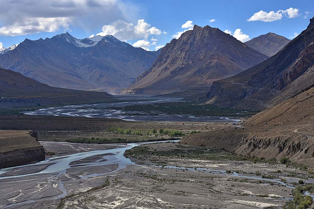
The Spiti valley is a remote, windswept cold desert with towering snow-capped peaks and awe-inspiring, sweeping vistas. It lies in the north-eastern part of Himachal Pradesh, flanked by Chinese-Tibet to the east and Ladakh to the North. It is a photographer’s delight, with spectacular canyons and stark, steep moonscapes that change color throughout the day. It is no surprise that Rudyard Kipling has described it in his book Kim as "a world within a world - a valley of leagues where the high hills were fashioned of the mere rubble and refuse from off the knees of the mountains... surely the Gods live here” Not only is the region famed for its astonishing beauty, it has an important place in the historical context with Spiti being an important hub of Trans Himalayan trade between India and Tibet before the war of 1962 caused a closure of the route and militarization along the border. It has also long been the home of stunning, ancient Buddhist monasteries of which Tabo monastery (over a thousand years old!) has the unique distinction of being the oldest continuously operating Buddhist enclave in both India and the Himalayas. The valley is also famous as being one of the rare places where the most elusive animal in the world, the snow leopard, may be spotted. It is also known as a place where you could stumble upon rare semi-precious stones and rock fossils, if you are lucky! If you thought things could not get any better, the real magic unfolds in night sky, as a million stars spread across it like a bejeweled carpet.
Short Itinerary
Day 1: Drive from Delhi to Shimla (350 Kms, 7 to 9 hrs), Overnight stay in hotel at Shimla.
Day 2: Drive from Shimla to Poh (385 Kms, 9 to 10 hrs), Overnight stay in hotel at Poh.
Day 3: Trek from Poh 3330 mtrs to Dhankar 3700 mtrs (14 Kms, 4 to 5 hrs), Overnight camping at Dhankar.
Day 3: Trek from Dhaula to Sewa 2050 mtrs(10 Kms, 4 to 4.5 hrs),Overnight Camping
Day 4: Trek from Dhankar to Lalung 3680 mtrs (12 Kms, 4 to 5 hrs), Overnight camping at Lalung.
Day 5: Trek from Lalung 3680 mtrs to Demul 4320 mtrs (12 Kms, 6 to 7 hrs), Overnight camping at Demul.
Day 6: Trek from Demul to Langza 4411 mtrs via Chame 4400 mtrs (16 Kms, 6 to 8 hrs), Overnight camping at Langza.
Day 7: Trek from Langza to Kibber 4120 mtrs (18 Kms, 8 to 10 hrs), Overnight camping at Kibber.
Day 8: Trek from Kibber to Ladarcha 4150 mtrs (11 Kms, 4 to 5 hrs), Overnight camping at Ladarcha.
Day 9: Trek from Ladarcha 4150 mtrs to Kiato 3950 mtrs (10 Kms, 3 to 4 hrs) and drive from Kiato to Manali (160 Kms, 4 to 5 hrs), Overnigth stay in hotel at Manali.
Day 10: Drive from Manali to Delhi (550 Kms, 10 to 12 hrs)
Essential: Do's and Don't / Things to Bring / Inclusion and Exclusion (PDF)
Spiti Left Bank Trek - Fact and Info (PDF)
Spiti Left Bank Trek - Detailed Itinerary (PDF)
Fact & Info
INTERESTING FACTS/INFORMATION ABOUT THE PLACE
Spiti Valley
The name Spiti can be translated as “The Middle Land” for it is the region that lies in between India and Tibet. Its ancient monasteries are a treasure trove of old Buddhist research and culture and has millennia old books that have been very well preserved, thanks to its extremely dry and cold climate. Among the many monasteries, the most famed are the Kyi (or Kii) monastery, which with its amazing cliff hugging design, is one of the most photographed; and the Tabo monastery, that is regarded as the Dalai Lama’s favourite. Among its sub-divisions, is the Pin Valley that due to its remoteness is the last sanctuary of the Buchen lamas of the Nyingmapa sect. The highest motorable pass is the Kunzum-La which, at 14,931 feet is the only access to the valley in winter, but can also get closed down for short periods of time due to snowfall. The valley is quite barren and tough to negotiate with an average height of 12,000 – 14,000 feet for most of its settlements.
Culture and Lifestyle –The people of Spiti are Biuddhist and their language belongs to the Tibetan language family. They used to practice polyandry but of late this is becoming rare with the advent of tourism and outside influences. The biggest festival is Losar (Tibetan new Year) and is celebrated with great joy during the months of either January or February, based on the “kaalachakra”, the Tibetan calendar. The villages are sparsely populated and the people here are hard working and practice potato farming or weaving. Owing to the harsh winters, the people still favour the nutritious salty butter tea and store dried meat for the long months with little or no access to greens. The houses are flat topped and built with a short squat profile, well spread out, since the region is prone to earthquakes. The design style is reminiscent of the Tibetan style and in places, you would be forgiven for thinking that post the Chinese invasion of Tibet, the true culture and Architecture of Tibet probably thrives here more as compared to Lhasa.
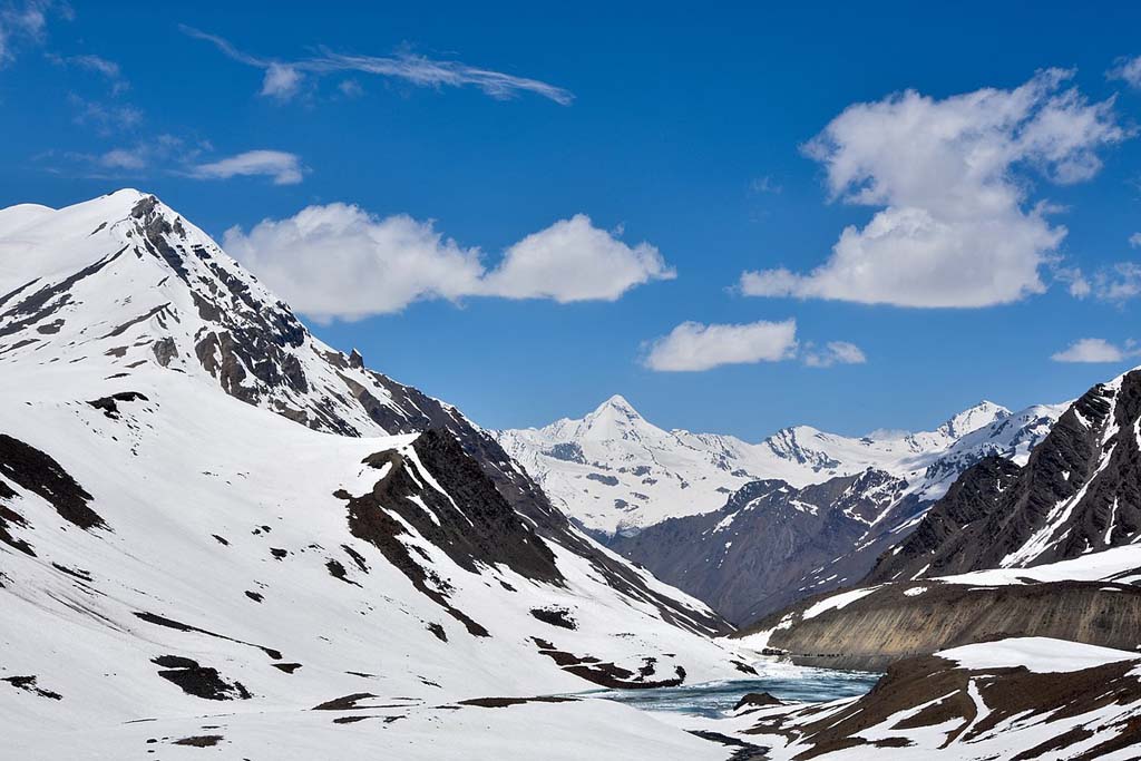
Geography –There is some amazing natural topography in this seemingly barren land. While going further north of Kaza (the district headquarters) you will see fantastic mesas and fluted rock canyons that are an adventurer’s delight. If you take the trouble to go on down to the Spiti river bank, you will see some fantastic multi-coloured, perfectly round shaped pebbles on the river bed and by its sides. They are green, blue, pink, maroon, purple… all kinds of fantastic hues, indicating the rich mineral wealth of the region. There are also a couple of truly breath-taking lakes in the region – the Chandra-Tal (moon lake) that actually falls in Lahaul district but is approachable from Kunzum Pass. It is a divine looking crescent shaped lake with emerald blue waters that change colour throughout the day. The other less-visited lake nestled away in the mountains, is the Dhankar lake. This is approached via a day trek from the town of Dhankar, home to the famous Dhankar monastery. Adding adventure are the stark peaks that surround the valley, some of which are also trekking peaks and are a rewarding excursion on their own. The best example is Mt. Kanamo (19,500 feet) which is accessible from Kibber where you can do a multi-stage trek upwards to the summit. Another exciting expedition is the Bara Shigri glacier that is the largest glacier in Himachal Pradesh, and also the second longest in India (after Gangotri) The Pin valley National Park that lies within Spiti is also the home of the elusive Snow leopard and the ibex and you can undertake expeditions set out to try and get a glimpse of the majestic creature.
Mythology –While there are many fantastic myths in the region, there is none more alluring than the story of the 600 year old mummified monk, Sangha Tenzin. About 80 kms east of Kaza, lies the village of Gue, where this naturally preserved mummified body of the monk can be seen, seated in deep meditation. The story goes that when his village was plagued by an infestation of scorpions, he decided to cease eating and slowly starve himself to self-mummification (a practice still followed by a sect in Japan) After he had been mummified naturally and his spirit left his body, it is said that a rainbow appeared in the sky and a kaleidoscope of butterflies appeared in place of the scorpions, who forever disappeared.
Spiti Left Bank Trek - Fact and Info (PDF)
Detailed Itinerary
Day 1: Drive from Delhi to Shimla (350 Kms, 7 to 9 hrs), Overnight stay in hotel at Shimla.
The first day involves a drive of 350 kms from the plains of Delhi up to the capital city of Himachal Pradesh, Shimla where we shall halt for the night. Do not miss the walk along the delightful Mall Road in the late evening! It is sure to charm you with its old-school, colonial ambience.
Day 2: Drive from Shimla to Poh (385 Kms, 9 to 10 hrs), Overnight stay in hotel at Poh.Today begins early, since this is a very long drive through rugged roads that will introduce you to the highlands along the Tibet border. The route winds upwards past Sarahan to Reckong Peo along the Sutlej river. Just before reaching Sangla, you will pass under the famed arched self-supported rock cutaway that is touted as one of the most dangerous roads! Further on, as the road turns left toward Reckong Peo, you will have stunning vistas on the right of the beautiful Kinner Kailash range. From here on, the road starts gaining height gradually as you enter the fringes of the cold desert. You will notice the vegetation getting sparse and the roads getting bumpier! By the time you reach Poh in the late evening, the transition from alpine country to a stark moonscape would be complete. The night will again be in a hotel with the trek scheduled to kick off from tomorrow.
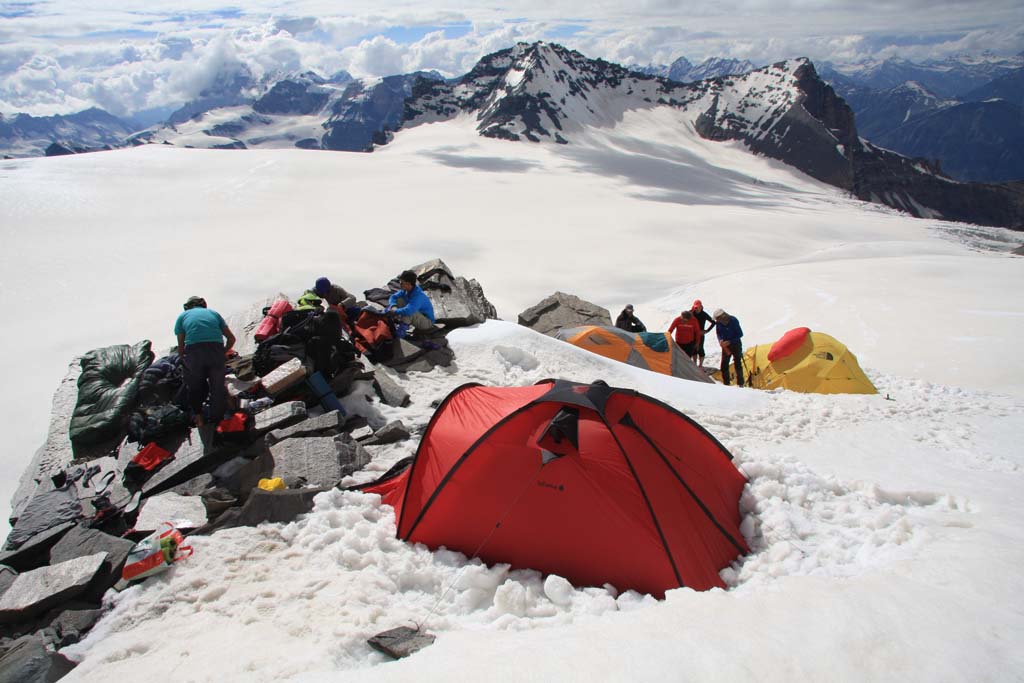
Day 3: Trek from Poh 3330 mtrs to Dhankar 3700 mtrs (14 Kms, 4 to 5 hrs), Overnight camping at Dhankar.The first day of our trek begins at a comfortable pace as we head out along the Poh maidan. The easy gradient carries on for about an hour before you come across the first tricky section of the Nipti nullah. Scramble down carefully down the slope and then up and over the other side. You can see a scattering of scrub land here, contrasting with the dry moonscape. The route carries on through the Paldang meadow and Nurpur village towards the dried Checham lake. The final test comes up once you have crossed the lake in the form of a steep slope, the Kharok nullah. After carefully traversing the slope, you finally descend down past Khorumchmik toward Dhankar. It is a pretty sight with the green cultivated fields contrasting with the canyon like rock walls guarding the village. The Dhankar monastery stands tall above the village, holding onto the scraggly scree slopes. The campsite is setup by evening as you settle into a well deserved rest.
Day 4: Trek from Dhankar 3700 mtrs to Lalung 3680 mtrs(12 Kms, 4 to 5 hrs), Overnight camping at Lalung.Today’s trek will be a relatively easy one, mostly along gentle gradients, and it affords the perfect opportunity to spend some time exploring the Dhankar monastery in the morning. The monastery and the fort above, are a photographer’s delight, affording sweeping views of the green plains fringing the river far below and the snow capped peaks far in the distance. Once the exploration is complete, the trek begins along a gentle slope that leads to a beautiful verdant pasture land near the mid way point called Tharpoley. Along the way are captivating views of the river Pin flowing down the opposite bank and joining the Spiti below. The final sector begins from here and it brings out a few pleasant surprises, the first being the refreshing glacial spring called Chhubu that will instantly take your tiredness away. A little further from here you will see one of the most beautiful and isolated villages of the Spiti valley, Demul, perched high up a seemingly inaccessible slope. From here, it does not take very long to reach our destination village Lalung where we will be camping for the night.
Day 5: Trek from Lalung 3688 mtrs to Demul 4320 mtrs (12 Kms, 6 to 7 hrs), Overnight camping at Demul.Morning can be spent having a quick tour of the Sarkhang monastery and exploring part of the ancient wall encircling it. From there on, we begin the long hard trail upto Demul village. The initial walk of approximately an hour and a half is fairly level and easy over a couple of bridges that span the Lingti river. The steep incline begins just past the village of Sanglung up scree slopes that make it extremely difficult. After a sustained effort climb, finally you come across the chhorten that signifies the entry to the village, after which it is just a matter of traversing through it to finally reach the campsite. This beautiful village is truly worth the effort, looking like an emerald pearl magically transported to a secret mountain top, flanked by steep rock walls below, green pastures all around and the majestic snow peaks of Manerang and Kamelang ahead.
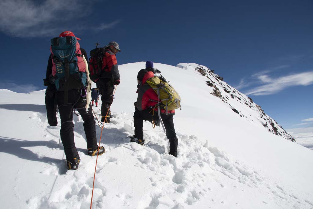
Day 6: Trek from Demul 4320 mtrs to Langza 4411 mtrs via Chame 4400 mtrs (16 Kms, 6 to 8 hrs), Overnight camping at Langza.Another tough day awaits with an ascent to the highest point of our trek and then the easier descent downward. It is advisable to drink and carry along a lot of water and a painkiller to help mitigate any symptoms of AMS (Altitude mountain sickness). Mild symptoms would be slight nausea or a headache and they will tend to go away as you start to descend. However if the symptoms are severe, you must report them to the trek support staff. Back onto the trek itself, we will begin climbing up through the meadows (where you may spot the elusive bharal) that ring Demul onto higher ground until we finally reach a snowy pass with Yanglapche being the highest point at 4,600 metres. This offers a spectacular view of the Chau Chau Kang Nilda peak (6,300 metres) that towers majestically above the villages of Langza, Komic and Hikkim. From this point you can see our path leading off in the distance to the Chame pastures below. Caution is advised while descending from Yanglapche since the slope is covered with hard packed snow and could be slippery. Once the snow stretch is crossed, it is a relatively easy descent, through the soft, mossy pastures of Chame onto the highest inhabited village in Asia, Komic. Pass thorugh Komic and carry on along a steady path to cross Hikkim and finally end up at Langza where we camp for the night.
Day 7: Trek from Langza 4411 mtrs to Kibber 4120 mtrs (18 Kms, 8 to 10 hrs) Overnight camping at Kibber.From Langza we carry on traversing above the Spiti river and proceeding further North West, there is a steep descent down the Shila Stream gorge after which begins the tough ascent out of it towards the settlement of Tashigong. This is more than 2000 feet of climb and can get pretty taxing. At the top of the ridge you can finally see the gentle slopes leading on towards Kibber village and the famous, extremely photogenic Kyi (or Kee) monastery. The route along the road is longer, but much more comfortable as compared to a short cut that leads directly down through steep cliffs. Kibber will be our camp for the night.
Day 8: Trek from Kibber 4120 mtrs to Ladarcha 4150 mtrs (11 Kms, 4 to 5 hrs), Overnight camping at Ladarcha.Today will be a fairly easy day as we will begin by travelling down the Parilungbi gorge. (a tributary of the Spiti river) Next, we climb up its opposite bank and circle past and around the right of the Chicham village. Opposite the village lies the Parang La, the pass used to cross over towards Ladakh. A gentle and easy walk will turn left gradually until the Spiti is back in sight and will lead you onto Ladarcha that is essentially a large open ground where festivals are held. This being an open pasture land, with time on our hands, its possible that we may sight bharal or the more exotic Tibetan snow cock. Either way, it is a good day to relax and enjoy photography.
Day 9: Trek from Ladarcha 4150 mtrs to Kiato 3950 mtrs (10 Kms, 3 to 4 hrs) and drive from Kiato to Manali (160 Kms, 4 to 5 hrs)The final day’s trek will be another easy one with most of the walking done along the road. Lower down on the opposite side, past cultivated terraces, you will be able to see the hamlet of Chikzur and the larger village, Pangmo. The route will climb gradually but its an easy rise, which is followed by a level walk for about an hour till you cross over the bridge and reach Kiato. This is where our trek ends and a vehicle will drive you to Manali. This drive is yet another adventurous stretch as the road climbs up to the stunning Kunzum La (pass) that separates the Lahaul valley from the Spiti valley. The car will go over Kunzum La and drive down through some incredibly rugged roads along the banks of the furious Chandra river. Between Batal and Chhatru, you will see the incredible Bra Shigri glacier flowing down all the way from the summit to the bottom of the massive. Beyond Chhatru, the landscape will finally start the change again and the hardy alpine trees will start making their comeback all the way up and over the Rohtang pass and into Manali.
Day 10: Drive from Manali to Delhi (550 Kms, 10 to 12 hrs)The final day has yet another adventure in store, with a long drive from the beautiful town of Manali to Delhi via the forests of Kullu, with the river Beas giving us company till Mandi. The road then leads on towards Chandigarh and finally ends up at Delhi.